


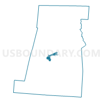
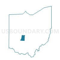
PRECINCT LONDON 3-A, Madison County, Ohio
About
Outline

Summary
| Unique Area Identifier | 649401 |
| Name | PRECINCT LONDON 3-A |
| County | Madison County |
| State | Ohio |
| Area (square miles) | 2.30 |
| Land Area (square miles) | 2.30 |
| Water Area (square miles) | 0.00 |
| % of Land Area | 100.00 |
| % of Water Area | 0.00 |
| Latitude of the Internal Point | 39.86957200 |
| Longtitude of the Internal Point | -83.44016180 |
Maps

Graphs
Select a template below for downloading or customizing gragh for PRECINCT LONDON 3-A, Madison County, Ohio


Neighbors
Neighoring Voting District (by Name) Neighboring Voting District on the Map
- PRECINCT DEERCREEK, Madison County, OH
- PRECINCT LONDON 2-B, Madison County, OH
- PRECINCT LONDON 4-A, Madison County, OH
- PRECINCT LONDON 4-B, Madison County, OH
- PRECINCT UNION EAST, Madison County, OH
- PRECINCT UNION WEST, Madison County, OH
Top 10 Neighboring County Subdivision (by Population) Neighboring County Subdivision on the Map
- London city, Madison County, OH (9,904)
- Union township, Madison County, OH (6,246)
- Deer Creek township, Madison County, OH (933)
Top 10 Neighboring Place (by Population) Neighboring Place on the Map
Top 10 Neighboring Unified School District (by Population) Neighboring Unified School District on the Map
Top 10 Neighboring State Legislative District Lower Chamber (by Population) Neighboring State Legislative District Lower Chamber on the Map
Top 10 Neighboring State Legislative District Upper Chamber (by Population) Neighboring State Legislative District Upper Chamber on the Map
Top 10 Neighboring 111th Congressional District (by Population) Neighboring 111th Congressional District on the Map
Top 10 Neighboring Census Tract (by Population) Neighboring Census Tract on the Map
- Census Tract 406, Madison County, OH (5,448)
- Census Tract 411, Madison County, OH (4,761)
- Census Tract 407, Madison County, OH (3,095)
- Census Tract 402.02, Madison County, OH (2,655)